Rock art at Thompson Springs begs the question: Why here?

Thompson Springs—the stretch of Interstate 70 between Green River and the Colorado Border in eastern Utah—with its undulating shades of monotonous beige and gray as far as the eye can see, is arguably one of the dreariest moonscapes anywhere. And most motorists are inclined to race through it as quickly as possible to reach the more colorful climes of Moab, Grand Junction or the San Rafael Swell.
It is hard to imagine stunning beauty and wonder hidden among these clay hills, but one of Utah’s greatest rock-art treasures is tucked a mere 15 minutes off the freeway and is easily accessible to even the wimpiest of vehicles.
Rock-art enthusiasts refer to this collection of painted and etched images as the Sego Canyon Site, although technically they are located in Thompson Canyon just below the point where it merges with Sego Canyon—about seven miles north of the almost-ghost town of Thompson Springs.
I first visited the site in the early 1980s when it was largely unknown except to a few die-hard rock-art lovers and generations of vandals who had desecrated it almost beyond recognition. In the years that followed, the Bureau of Land Management invested tens of thousands of dollars to hire a rock-art conservator who painstakingly removed the graffiti while restoring the mysterious images to their prehistoric glory.
Today, the site features walking trails, a formal parking area, information kiosks, and a cadre of site stewards who monitor and protect it, interacting with a growing flock of visitors who make the short jaunt north of the interstate to marvel at 3,500 years of prehistory on these unimposing sandstone walls.
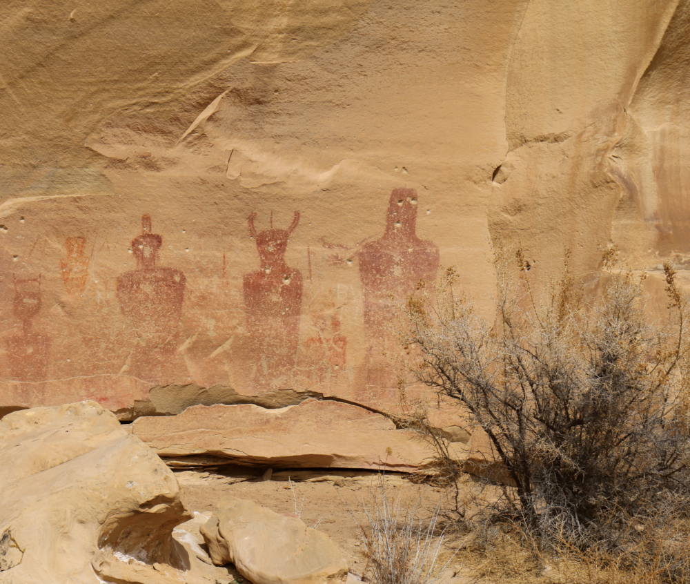
On the north end, you’ll see a grouping of ghostly red figures, many nearly life-sized human figures executed in a style called Barrier Canyon, named for a canyon in Canyonlands National Park where they are found in abundance. Most archaeologists believe these are evidence of Utah’s earliest hunters and gatherers from about 2000 B.C. to about 400 A.D.

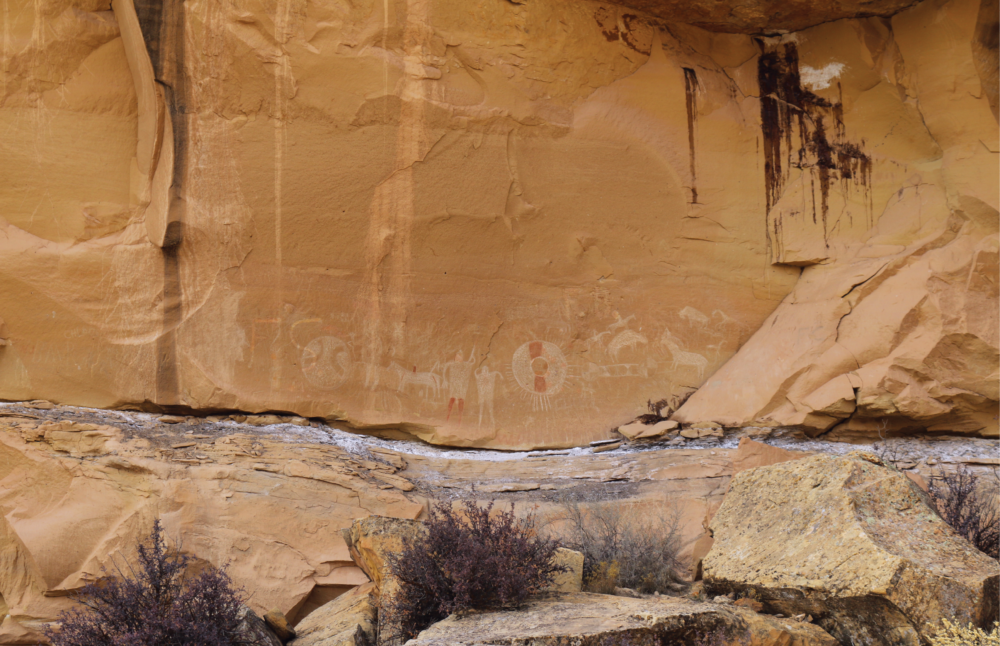
As you walk along the trail to the southwest, you’ll notice another cluster of images high on the cliff wall—precisely pecked triangular humans depicted with ornaments and jewels that are reminiscent of the Fremont Complex anthropomorphs found in the Capitol Reef area and somewhat similar to those in the Vernal area far to the north. These were probably left by the first farmers in the region between about 600 and 1250 A.D.
And then, as you follow the trail to the west, you will see vivid red and white circles, believed to represent the first Ancestral Utes in the region—hunters and gatherers who might have arrived in this region about 1300 A.D. and were still here when the first Euroamerican explorers arrived in the early 1800s.
It’s one location with three cultures, each with a remarkable visual record of their sojourn in this bleak landscape.
As you marvel at the images—and there are hundreds if you pay close attention to the compositions—it is natural to ponder the question, “Why here in the middle of nowhere?”
Archaeologists have some ideas but no definitive answers. The site is located at the mouth of a minor canyon that offers access to the high East Tavaputs Plateau country to the north above and beyond the Book Cliffs that stretch along the east and north side of the highway all the way from Price to Grand Junction.
The Book Cliffs are not easy to penetrate, and those few locations offering easier access to the high country might have been preferred transportation corridors through all generations of prehistory. Well-known corridors through the Book Cliffs have been documented near Price (providing access to Nine Mile Canyon), near Horse Canyon (providing access to Range Creek), and a short distance east of here through Westwater Canyon, the preferred route of fur trappers in the early 19th century.
But none of these better-known routes have the signatures of three cultures, at least not in such awe-inspiring grandeur.
For reasons archaeologists do not understand, this minor, unassuming location was a magnet for prehistoric peoples, a place where they returned repeatedly to portray their thoughts, their experiences, and their way of looking at the world. There is not much here in terms of foods that could have been harvested, and it would have been a miserable environment to try to raise corn.

So why here? The answer might require generations of future research. And until the answers can be teased from the archaeological evidence, we must be content to marvel and wonder and appreciate the past for what it is: A wonderland of mystery and uncertainties.
Visiting the Sego Canyon rock-art clusters is remarkably easy. Take I-70 to exit 187 for Thompson Springs exit. Follow the only road through Thompson Springs—now mostly deserted—and continue on the only main road as it winds its way north. The site is next to this main road about seven miles north of the town and is impossible to miss.
There’s a walking trail between the three main clusters of images, but also take the time to wander along the opposite side of the canyon where there are other clusters of oversized red Barrier Canyon images. Some of these are located on private land, so be respectful and observe close by from the road. Plan on about two hours to enjoy the entire site, although it can be experienced in far less time if you are in a hurry (it is also well suited to young children).
As with all rock-art, remember to never touch the images in any way. And bring a telephoto lens to capture photos high on the cliff faces.
The main site is located on BLM land, although there is precious little on the BLM web page about it. The public has become increasingly fond of this site, and there are dozens of online links to travel reviews and blogs (type in Sego Canyon rock art or Thompson Springs rock art).
Services are quite limited in this area. There is a gas station/convenience store next to the freeway exit. Haul away your own trash, remember to take plenty of water and treat the past with respect.
Jerry D. Spangler is an archaeologist and executive director of the Colorado Plateau Archaeological Alliance, a nonprofit dedicated to preserving cultural resources on public lands in the West.


