Exploring shades of autumn in the Stansbury Mountains
By Levi Rogers
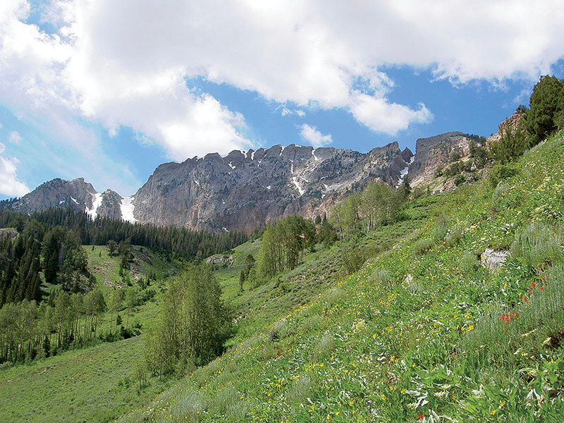
They’re hard to see from the Salt Lake Valley, obscured as they are by the more immediate Oquirrh Mountains, but the Stansbury Mountains are a tucked-away little jewel of a mountain range an hour’s drive west of Salt Lake just outside Tooele and Grantsville.
Here you’ll find beautiful hiking, camping, fishing, climbing and even skiing. The crowds are sparse, and the terrain is as inviting as anything you’ll find in the Wasatch canyons. Camping with friends and family here is always a memorable experience.

Stansbury Mountains
Getting There
The Stansbury Mountains extend 28 miles in eastern Tooele County, offering trails, mountain climbing and camping. To get there, take I-80 west from Salt Lake City to Exit 99 for Tooele/Stansbury. Drive south for 3½ miles along SR-36 until you get to UT-138. Take a right and head the 11 miles or so to Grantsville. Turn left on West Street at the end of town, which becomes Mormon Trail Road (follow the street signs). Drive approximately 3½ miles south to get to North Willow Canyon or 5 miles to South Willow Canyon. Turn right, or west, and head up the canyon.
Canyons to Explore
The two main canyons of this mountain range are South Willow and North Willow. North Willow is available for dispersed camping in the summer, while South Willow is more developed and has the main campground and picnic sites. In the fall and summer, there are some beautiful hikes up each canyon and even some backcountry skiing in the winter. A prime group site is called the Upper Narrows Campground—it’s a walk-in site with a capacity for over 50 people and is reached by crossing a bridge over the river. The canyon’s last campground is Loop Campground, which is also the trailhead for Deseret Peak.
Rock Climbing
In the spring, summer and fall, there’s some hard-ass rock climbing in a section of the Stansbury Mountains called the Narrows. Located in South Willow Canyon alongside a gentle river, it features some four-star 5.12 and 5.13 climbs. There are a couple 5.9s but, mostly, you’ll encounter challenging sport climbs on limestone. It’s helpful to bring a stick clip as most of the climbs are directly above the river. It’s hot in the summer but somewhat shady and cool in the fall and spring.
Deseret Peak/Fall Colors
A must-do for those trying to bag all the high peaks in Utah, Deseret Peak is an 11,031-foot-tall peak in the Stansbury Mountains, the highest in the range, and the area’s prime attraction. While the hike is only 7.4 miles round trip, the trail is steeper and longer than you think, like many hikes in the Wasatch. You gain 3,613 feet in elevation. Rated moderate to difficult, it took a group of four of us nearly eight hours to hike to the summit and return to camp at the Upper Narrows. However, others have been known to run the trail in a few hours.
Is it worth it? Absolutely. The trail starts in some dense trees before spitting you out into wide open meadows full of wildflowers. Eventually, you ascend a small ridge and begin making your way along the mountain’s rocky spine toward the summit. Summer and fall are the best times to hike. Summer offers vistas of wildflowers and fall offers colorful trees. From the top of Deseret Peak, you can see Utah’s entire West Desert stretching all the way to Wendover and Wendover Air Force Range.
How to get there: The Deseret Peak Trailhead is located at Loop Campground at the top of South Willow Canyon. To reach South Willow Canyon Road from Grantsville’s Main Street (UT-138), head south on Mormon Trail Road for 5.2 miles. Follow the signs and turn right onto South Willow Canyon Road and proceed west up into South Willow Canyon. Loop Campground is 8 miles ahead. You’ll pass several campgrounds along the way. There are multiple variations and hikes on Deseret Peak to ensure that you won’t get bored.
Backcountry Skiing
Those looking for more adventure can hike up the trail in the winter if you have experience (although it would be best to wear crampons and carry an ice axe if you plan to go all the way to the top of the peak). You can also ski down the Twin Couloirs near the top of the ridge. You might need to park farther away in the winter as the road is not quite plowed all the way to the trailhead, but it also means it’s a great place for snowmobilers.
Visit TooeleCountyTrails.com for trail maps, trail updates and more.


