The discovery of rock art at Fish Creek Cove gave the Fremont culture its name
Story and photos by Jerry D. Spangler
For a thousand years—beginning about AD 200—give or take a couple of centuries—almost the entire state of Utah north of the Colorado River was home to what archaeologists call the Fremont culture, a name applied to ancients who were especially adept at shifting their subsistence between farming, hunting and gathering wild plants. They also left behind rock art images that rank among the best anywhere in the world.
Fremont is simply a name that archaeologists use to communicate with each other and the public. We don’t know what they called themselves, and we don’t know for certain what became of them, although DNA tests suggest some were related to Puebloan peoples of modern-day Arizona and New Mexico.
So why are they called by the very non-Native American name Fremont? We have to go back to 1928 to find the answer to that question. That was the year that the Peabody Museum at Harvard University launched the first of four expeditions to explore the canyons north of the Colorado River, a region at that time rumored to be rich in spectacular ruins.
In 1928, most members of the Peabody Museum expedition mounted their horses and set off to explore Boulder Mountain and the Kaiparowits Plateau. But one member, Noel Morss, remained behind in Torrey (just outside of Capitol Reef National Park) and, with the help of local residents, began excavating alcoves along the Fremont River. Those excavations led Morss to write an influential monograph titled Ancient Culture of the Fremont River in Utah.
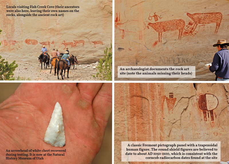
Most of Morss’ monograph was based on his excavations at Fish Creek Cove, a picturesque shelter located on the backside of the Cocks Comb south of Torrey, in between Teasdale on the west and Grover on the east. The shelter was well known to locals, many of whom had added their own names and dates to the shelter walls. Morss’ excavations were exhaustive: Some historic photos depict massive pits perhaps 6 feet deep.

The most striking feature at Fish Creek Cove is a row of nearly life-size red, four-legged critters that are missing their heads. And for added effect, the ancient artists deftly added drops of red pigment that seems to depict dripping blood. The areas where the heads would have been rubbed smooth, as if a head had once been there only to be erased, perhaps as part of rituals. There is nothing quite like this site anywhere else.
Morss uncovered evidence that Fish Creek Cove was likely occupied repeatedly, probably over a long period of time given that thousands upon thousands of artifacts were present here. He also uncovered the remains of various structures, all indicative of a small community of no more than a few families.
Fish Creek Cove would have been an idyllic setting: It is south-facing and would have been warm in the winter; it is close to Fish Creek and its Spring Branch tributary, a source of permanent water even during droughts; and there were places along the creeks and perhaps in the sage flats where they could have cultivated maize, even though the 7,000-foot elevation would have made it difficult.
Several years ago, archaeologists—myself among them—revisited Fish Creek Cove, and we obtained several radiocarbon dates, all representing activities between AD 900 and 1150, or near the end of the Fremont occupation in central Utah. And we found that even though Morss had been quite thorough, important information remains here for study by future scientists.
Fish Creek Cove, located on public lands administered by the Bureau of Land Management, remains a popular destination for Wayne County residents who still marvel at the mysterious rock art images where meaning has been lost to the passage of time.
To visit the site, drive south from Torrey on Highway 12 about 3 miles and take the turnoff on your right to Teasdale. Go about a mile and look for a turnoff on the south side of the road (Fish Creek Cove Road on maps, but it’s easy to miss on the highway). Proceed south on this narrow dirt road about a mile to the pullouts at the end of the dirt road and then follow the trail about 50 yards to the site itself.
The road, which provides access to a cluster of homes just east of Fish Creek Cove, does not require four-wheel drive, but it can be rough after bad weather, and higher clearance cars are recommended. There are a few spurs off the dirt road that lead to residences, but just stay right.
Fish Creek Cove has seen 140 years of graffiti and vandalism, some of it quite recent. Never add your own names, dates, or other inscriptions. Artifacts such as potsherds and stone flakes are also abundant here. It is certainly acceptable to photograph them, but it is a federal crime to remove them.
This site is protected by federal laws intended to preserve these resources for future generations. Local residents and site stewards are friendly, but they also keep a watchful eye.
For those thirsting for more detailed information on Fish Creek Cove, Noel Morss’ 1931 monograph is still in print and available on Amazon.
Jerry D. Spangler is an archaeologist and executive director of the Colorado Plateau Archaeological Alliance, a non-profit dedicated to protecting cultural resources on public lands in the West.


