Exploring the splendid isolation of Paria Canyon-Vermilion Cliffs Wilderness
By Kathleen Curry and Geoff Griffin
One way—perhaps the best way—to see Utah birds, animals and fish is to visit the places in which they live. Utah’s 31 national wilderness areas allow wildlife to exist at its most wild. Signed by President Lyndon B. Johnson, The Wilderness Act of 1964 set aside more than 109 million acres in 760 areas throughout the nation to be preserved as pristinely as possible. “If future generations are to remember us with gratitude rather than contempt,” President Johnson said, “we must leave them a glimpse of the world as it was in the beginning, not just after we got through with it.”
National wilderness areas in Utah are, in essence, fragile ecosystems hosting wildlife that often cannot be observed elsewhere. The lands also have the advantage of flying under the radar when compared with popular national and state parks that tend to be more crowded. To visit, you often need to travel by foot or horseback to avoid creating the noise or commotion of motorized recreation.
One of most beautiful national wilderness areas in Utah is the Paria Canyon-Vermilion Cliffs Wilderness, found along the Utah-Arizona border. Its 112,500 acres are well-known for vistas of brilliant multicolored walls and waves of sandstone, but it’s also a place to find abundant wildlife. Visitors can observe birds—including golden and bald eagles, mammals such as the desert bighorn sheep and reptiles like the desert spiny lizard.
A great way to experience Paria Canyon-Vermilion Cliffs is to create a weekend trip based in nearby Kanab, which sits just inside the Utah border. Kanab is also popular for those wanting to visit or volunteer at Best Friends Animal Sanctuary, an experience we’ve covered in “Southern Comfort” in our December 2018 issue. Our focus in this issue is to look for wild beings on their own turf.
Thursday
Afternoon
Salt Lake City to Kanab
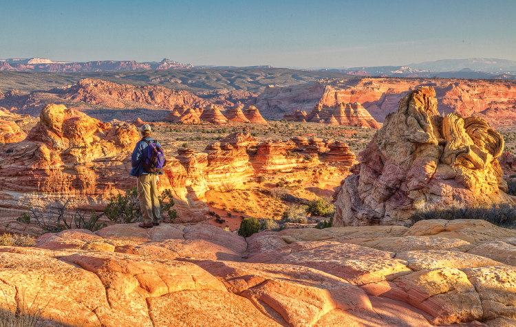
Vermilion Cliffs vistas
The drive to Kanab from Salt Lake City is just over 300 miles, so plan on roughly a 4½-hour drive. Take Interstate 15 south out of Salt Lake past Beaver and then take Exit 95 onto Utah State Route 20. That road connects with U.S. Route 89, a road that winds south into Kanab. Once on U.S. 89, before arriving in Kanab, a dinner stop in the town of Panguitch will not disappoint.
Located in a historic building, the Cowboy’s Smokehouse Cafe (95 N. Main St., Panguitch, 435-676-8030, TheCowboySmokehouse.com) is a family-owned barbecue spot that, since 1993, has been serving up platters of mouth-watering Texas-style barbecue with sides. Also on the menu is a 24-ounce Porterhouse steak and fresh rainbow trout.
Night
Kanab
In the mid-20th century, Kanab served as a location for many Western movies. To house the crews, a handful of motor lodges were constructed, which at that time, were the height of modern luxury travel. Decades later, several of these lodges have been restored to 21st-century standards along with amenities of the modern world. Two favorites include The Flagstone Boutique Inn & Suites (223 W. Center St., Kanab, 844-322-8824, TheFlagstoneInn.com), with fully equipped kitchens, and Quail Park Lodge (125 N. 300 West, Kanab, 435-215-1447, QuailParkLodge.com), featuring an outdoor swimming pool and outdoor seating that exposes guests to cool breezes on a summer evening.
Friday
Morning
Kanab to Paria Canyon
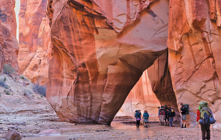
Buckskin Gulch,
one of the longest slot canyons in the world
Kanab Creek Bakery (238 W. Center St., Kanab, 435-644-5689, KanabCreekBakery.com) opens at 6:30 a.m. for croissants and baguettes made by a genuine Belgian baker named Marjorie Casse. She wanted to bring the food and feel of classic European patisseries to the beautiful landscapes of Southern Utah. If you’re craving more than pastries, check out the brunch menu that features quiche, crêpes and a “Croque Hawaii”—a croque monsieur with pineapple.
After breakfast, it’s time to head east of Kanab on U.S. 89 for about 40 miles to Paria Canyon (435-688-3200, BLM.gov/visit/paria-canyon-vermilion-cliffs-wilderness) where you’ll see signs to the White House Trailhead Road. Once you arrive at the trailhead, you’ll find a hiking “trail” that winds back and forth through the canyon’s river, so bring appropriate shoes and clothes. For a shorter, less-strenuous hike, trek about 4 miles following the river, then turn and head back for a round trip of 8 miles. If you want something more challenging, keep going after the fourth mile as the river creates an ever-deepening slot canyon. While this part is more difficult, it can be more rewarding as the sandstone walls rise higher and higher above the river.
At about 7 miles in, Paria Canyon merges with Buckskin Gulch, a dark narrow canyon that extends for nearly 13 miles and is said to be one of the longest slot canyons in the world. Hiking the gulch is often part of a two-day canyoneering and backpacking adventure. However, for day hikers, reaching the gulch means it’s a good time to turn back, resulting in a 14-mile hike.
There are several things to consider when visiting any national wilderness area. Visitors need to bring their own water and have a plan for disposing of human waste. There will not be staff on hand to assist or give information the way there would be in a national or state park. Cellphone service is not dependable, so you should have your own maps for navigating.
When it comes to traveling in the Paria Canyon-Vermilion Cliffs region specifically, note that during the summer months, the temperatures can be hot, and the beautiful rock canyons don’t offer much shade. It’s also important to check the weather before venturing out. Rainstorms, particularly during dry months, can cause flash flooding in Utah slot canyons.
While we are suggesting day hikes for this itinerary, keep in mind that multiple-day backpacking trips can be planned from one canyon to another. The number of people allowed to camp overnight in the area is limited, so check with the Bureau of Land Management to determine if a permit is required.
Night
Kanab
Upon returning to Kanab after a day of hiking, fill up at Escobar’s Mexican Restaurant (373 E. 300 South, Kanab, 435-644-3739). It’s one of those classic Mexican restaurants where, when you ask your server for recommendations, they say, “One of everything.” Get a platter and mix it up with a chicken enchilada, pork burrito and shredded beef taco along with rice and beans and complimentary chips and salsa.
Saturday
Morning
Kanab to Buckskin Gulch
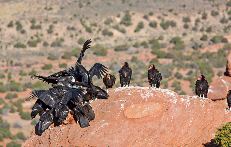
California condors were reintroduced at Vermilion Cliffs in 1996
One of the ways to get a sense of Kanab’s Western history and tradition is to grab breakfast at Houston’s Trail’s End Restaurant (32 E. Center St., Kanab, 435-644-2488, Houstons.net), which opened in 1945 and has been owned by the same family since 1975. The breakfast menu includes pancakes, French toast and three-egg omelets, but the place is best known for “Bob’s country gravy.” They make 10 gallons of the stuff every day (seriously) and serve it on breakfast biscuits, among other items.
After breakfast, opt to return to Buckskin Gulch, which you caught a glimpse of on Friday. Head east on U.S. 89 again, but this time turn off on House Rock Road between mileposts 25 and 26. (Note: House Rock Road, while unpaved, is normally passable by passenger cars when dry, but you’ll need 4WD if the road is wet.) Take House Rock Road for 8.4 miles to the Wire Pass parking area and trailhead. From the trailhead, it’s a 1¾-mile walk to reach Buckskin Gulch.
The gulch’s sandstone walls gradually grow taller while the hiking trail gets narrower, making this more difficult hiking terrain than you experienced in Paria Canyon. Apply the same rules, though, for hiking, including staying out of the heat and being aware of potential rain. For a day hike, follow the 12-mile gulch as far as you wish before turning back.
Along the way, keep an eye out for wildlife, including California condors that were bred and released in 1996 in an attempt to reintroduce them to the wild.
Night
Kanab
Following your hikes in the wilderness, you’ve more than earned a carbo-load. But this isn’t just any run-of-the-mill dinner stop. Vermillion 45 (210 S. 100 East, Kanab, 435-644-3300, Vermillion45.com) serves slow-cooked, homestyle French, Belgian and Italian dishes as well as nouvelle cuisine, fresh seafood and steaks in a casual bistro setting. Beer, cocktails and wine by the glass are also available. Highlights from the dinner menu include sea scallop risotto and gnocchi served with meatballs.
Sunday
Morning
Kanab to Coyote Buttes North (The Wave)
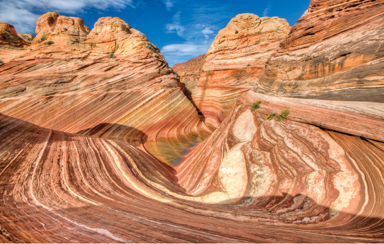
Coyote Buttes North, known as The Wave
At this point, you may be asking, “What about The Wave?” as it’s the most well-known attraction in the Paria Canyon-Vermilion Cliffs Wilderness. Coyote Buttes North, aka The Wave, is a surreal landscape that appears to be a sea of rolling red waves, but is, in fact, beautifully multicolored, layered rock.
Catching The Wave requires first getting a permit. Coyote Buttes North has become so popular that the BLM now limits the number of visitors to 20 per day. Ten of those spots go to those who apply online in advance in a BLM lottery. Chances of winning the online lottery range from around 4% for the peak months up to 25% for winter months.
Getting one of the other 10 daily spots requires stopping at the Grand Staircase-Escalante National Monument Visitor Center (745 E. U.S. 89, Kanab, 435-644-1300, BLM.gov) the day before you want to hike to sign up for a walk-in permit. If more than 10 people apply, a drawing is held. There are intricate rules for getting these spots, which you can learn about at BLM.gov or by calling the visitors center.
The hike itself is about 6 miles round-trip and will take about five hours. Wire Pass Trailhead—about 40 miles east from Kanab, which you took to access Buckskin Gulch—is also the most recommended access point for Coyote Buttes North.
While it can be difficult to get a permit for Coyote Buttes North, there is also Coyote Buttes South. Entrance to these beautiful rock formations and coves is also limited to 20 people per day and has an online lottery and walk-in drawing held at the same visitor center in Kanab. However, permits to Coyote Buttes South are generally easier to obtain. Both are remote wilderness areas and, to reach trailheads, vehicles with high-clearance 2WD or 4WD are strongly recommended.
Afternoon
Coyote Buttes North to SLC
Heading north on U.S. 89 en route to SLC, you’ll pass through the town of Orderville, about 24 miles away from the trailhead. When you’re driving on a two-lane highway through rural Utah, you probably aren’t expecting to see a German bakery sitting alongside the road. Therefore, you could be surprised to see a large, modern building with a sign that says Forscher German Bakery and Café (110 N. State, Orderville, 435-648-3040, ForscherGermanBakery.com)
Once you get over your initial shock, pull over and venture inside to taste German rolls, breads and pastries. Or enjoy breakfast dishes, sandwiches and German beers. Note that Forscher is generally closed November through March.
!!!
Now that your desert journey has ended, we hope you kept a list of the wildlife you may have glimpsed: bighorn sheep, falcon, mice, fish, deer, owl, frogs, lizards, scorpions or rattlesnakes, perhaps? Don’t forget native insects and spiders, as in the black widow, centipede, flies, gnats, ants and, yes, even the tarantula. All of these creatures manage to co-exist upon these delicate lands, a thought worth pondering while trekking a lonely desert trail.


