A visit to Utah’s Cedar Mesa can transport you to an ancient time and people.
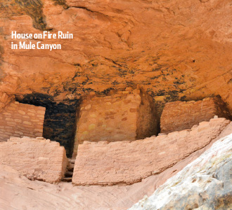
The instructions were vague, at best: Drive along a rutted two-track Jeep trail to an obscure crossing, turn north and drive to the end of the trail at the rim of a canyon unnamed on the topographic map. Then work your way to the bottom of the canyon, and you’ll find the ancient ruins of the Ancestral Puebloans tucked just under an overhang on the north canyon wall.
Before me was Moon House, the remains of an 800-year-old community where the ancient ones had painted phases of the moon on the interior walls of one residence. The indescribable thrill of discovering something so beautiful and so mysterious has remained indelibly imprinted on my consciousness.
 That was some 30 years ago—when only a handful of people even knew about Moon House. In a sense, we were a tight-knit community that cautiously guarded its secrets—especially how to find it. There were no trails to Moon House in those days, and fewer than two dozen people ventured there in any given year.
But that was before the genie escaped the bottle. First came a slew of guidebooks that not only trumpeted the glories of Moon House and scores of other, equally thrilling locations on Utah’s Cedar Mesa, but they often revealed detailed instructions on how to get there. And more recently, virtually every “secret” site in the region has been revealed through internet postings.
Hundreds of people now visit Moon House every year, and thousands upon thousands visit the ancient ruins of Cedar Mesa and the nearby Abajo Mountains, Bears Ears and Natural Bridges areas. In summer 2016, Sally Jewell, the U.S. Secretary of the Interior, and her entourage even visited Moon House as part of a fact-finding mission.
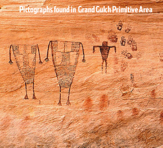
Why all the fuss? Quite simply—with the region’s myriad cliff ruins and rock art, all nestled in a spectacular setting of brilliant red rock canyons—the area is a wonderland. It’s not surprising that preservationists—concerned about the onslaught of public visitation and the consequent deterioration of the ancient sites—are advocating for President Barack Obama to designate the entire region a national monument (visit BearsEarsCoalition.org/proposal-overview/).
A national monument designation could result in additional funding to more proactively manage the estimated 100,000 archaeological sites here for their long-term protection, but the political fallout in San Juan County—a hotbed of anti-federal-government sentiments—would be immeasurable, and local hostility is never a good recipe for site protection.
 The best way for people to decide the merits of any designation is to see it for themselves.
And there are several ways to enjoy the Cedar Mesa region:
• The best way to get up close and personal with the archaeology here is to spend a few days backpacking into the different canyons. The most popular backpack destination is Grand Gulch, but other trails include the Fish-Owl Canyon Loop, Slickhorn Canyon, Arch Canyon and Mule Canyon. Overnight camping permits are required and are available at the Kane Gulch Ranger Station
• For those averse to the strenuous demands of backpacking, car camping with different day hikes each day is a great alternative. Virtually every canyon in this region is teeming with spectacular ruins, and for the adventurous, it all comes down to choosing which canyon to explore. The first step is to order a copy of “Trails Illustrated Grand Gulch Plateau Map No. 706” and then narrow your choices. My personal favorite for day-hiking is Natural Bridges, and for car camping it is Butler Wash, which has scores of side canyons (the mouth of Butler Wash is nothing short of jaw-dropping). Bureau of Land Management permits are not required for car camping.
• Several impressive sites are located next to the highway and have designated vehicle pullouts for those short on time. One good set of cliff ruins can be seen where Utah State Route 95 crosses Butler Wash. If ancient rock art is your bag, you can’t go wrong with a visit to the Sand Island Campground on the outskirts of Bluff (campground information is available at BLM.gov). Other must-see stops include Edge of the Cedars State Park in Blanding and the Mule Canyon Ruin, also along State Route 95. Decent motel accommodations can be found in Blanding, Bluff and Mexican Hat.
• You can also take a float trip on the San Juan River. Commercial river guides know all the great stops along the way to explore ancient ruins and rock art sites. It is an easy river to float on your own, but you will need to be lucky enough to draw out on a limited number of permits.
 This region is almost entirely public lands managed by the BLM, the National Park Service or the U.S. Forest Service, with a scattering of School Trust Lands in the mix. Hiking and camping are encouraged but there are a litany of rules and regulations depending on where you go and what you do when you get there. At BLM.gov, you can download an excellent Cedar Mesa-Grand Gulch Trip Planner that summarizes the rules and regulations.
Whether you support or oppose a national monument designation, all can agree that Cedar Mesa is one of America’s richest archaeological treasures. Seeing is believing.
The author is a professional archaeologist and director of the nonprofit Colorado Plateau Archaeological Alliance, an organization dedicated to preserving ancient sites on public lands in the West.


