The Jordan River, Salt Lake’s urban waterway, continues to reinvent itself
We usually think of recreational waterways as stretches of water surrounded by acres of wilderness, but along the Wasatch Front, the Jordan River and its adjacent parkway defy that description. This urban recreational waterway is highly accessible, easily reached by walking, biking, UTA bus or TRAX, depending on where you live. Here’s some information about this important feature of the Wasatch Front landscape.
History
When the LDS pioneers arrived in the Salt Lake Valley in 1847, they found a river winding through their new home, which Heber C. Kimball named the “Western Jordan.” They used it to float blocks of granite with which to build the Salt Lake Temple, and the Jordan played a role in transporting goods used in building 19th century railroads. In the 20th century, the waterway mainly was used as a dumping ground for nearby businesses until the 1970s, when state and federal laws helped to halt the pollution.
In 2008, a group of people formed the Jordan River Commission and began a “vision process” to turn the Jordan into an urban recreational area. That vision was completed in 2017, and today, the Wasatch Front has a recreational outlet that connects three counties.
Facts
The Jordan River Parkway is a continuous 40-mile paved trail that runs adjacent to the river, which flows north from its headwaters at Utah Lake in Utah County through Salt Lake Valley. The parkway links up with the Legacy Trail in Davis County, ending near the Great Salt Lake. In all, the parkway touches 15 municipalities. In Salt Lake County, it runs through nine city parks, one county park and three golf courses. The nonmotorized trail is open to hiking and biking and provides access to the river.
Resources
When out on the trail, you can pull out your mobile device and visit MyJordanRiver.org. Although it’s technically not an “app,” it operates like one on your phone and allows you to navigate your route along the river.
If you’re looking for information about where to go along the river, check out JordanRiverCommission.com/thetrail and then click on the link for Jordan River Parkway Spotlights under the Destinations section.
Information about the parks and trails the river touches on in Salt Lake County can be found at SLCO.org/parks/trails.
If you are wanting to take a bicycle on the trail, check out BikeSLC.com/jordanrivertrail.

Animals
A variety of wildlife live above, in and around the Jordan River. More than 200 species of birds can be found along the waterway, depending on the time of year. The list includes traditional birds associated with water like geese, herons and gulls, but also doves, owls and hummingbirds.
On the ground, beavers, foxes and deer can be found in different areas along the path. Closer to the water, look for bullfrogs, toads, turtles and salamanders. In the water, you can still find native species such as the Utah sucker, but invasive common carp have come to dominate in recent years.
Highlights
If you’re hiking or biking the trail, consider stopping off and checking out these spots that are either right along the river or a close walk nearby.
International Peace Gardens (1060 S. 900 West, SLC, 801-972-7800, InternationalPeaceGardens.org) Located just minutes from downtown Salt Lake, this beautiful park has a goal of fostering peace in the world by dedicating space to the gardens, statues and architecture of over two dozen nations.
Utah Cultural Celebration Center (1355 W. 3100 South, West Valley City, 801-965-5100, CulturalCelebration.org) This cultural center provides an inclusive space for groups of all ethnicities and backgrounds to come together in unity. Regular art and craft displays in the gallery are open Monday-Saturday and are free to the public. The center also has a regular schedule of concerts and events that can be found at CulturalCelebration.org.
Jordan River Migratory Bird Reserve (500 W. 9800 South, South Jordan, JRF-Utah.org) These 120 acres of riparian habitat were restored in 1997 and serve as a temporary home for birds migrating from Canada to South America.
Fishing
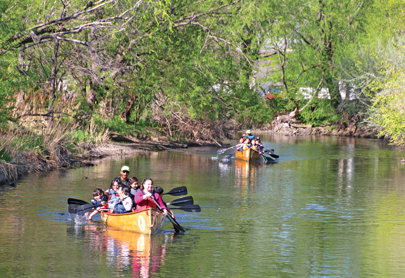
Hiking or biking alongside the river is beautiful, but if you’d like to actually get in or cast a fishing line, check out the map at JordanRiverCommission.com/the-river to find out where you can park, launch a kayak or canoe, or fish. Top fishing areas include the headwaters of the river coming out of Utah Lake or Sandy Pond Fishery, a 3-acre body of water located at 1000 W. 9800 South in Sandy.
Jordan’s Water A variety of sources
Utah’s Jordan River winds through a valley booming with more than 1 million people. The hardworking river has long been engineered to serve the city’s residents. But even as an urban river, the waters are not necessarily depleted as they flow through the city. New research by a University of Utah team led by professor Jennifer Follstad Shah shows natural waters continue to infuse and refresh the Jordan River.
The 51-mile-long Jordan River—stretching from Utah Lake in the south to the Great Salt Lake in the north—has, since the mid-1800s, been engineered to provide irrigation, drinking water and waste disposal for the Salt Lake Valley. All that usage took a toll on the river’s oxygen levels. Its low levels put the river on the EPA’s list of impaired waters, which is how Professor Shah came to be involved.
The microbial ecologist wanted to understand the relationship between river water quality, microbes and oxygen levels, and especially how urban river systems such as the Jordan respond to what Shah describes as “chronic inputs of carbon and nutrients.”
In 2016, Shah’s team collected samples from 18 sites along the river, expecting to find (through isotope signatures) water sourced from Utah Lake, tributary streams and water reclamation plants. But, surprisingly, Shah’s study found there were significant natural sources of water, including groundwater, in the Jordan River.
The changing sources of water affect the look of the river. “It’s pretty turbid and in some places looks rather green, like Utah Lake,” Shah says. “Whereas, if you’re at a [reclamation plant] discharge point, you see that the water looks much clearer, like the tributaries.”
The study helps us better understand how water travels from the Wasatch Range and through the Salt Lake Valley. “The paradigm was that we get snow that falls on the mountains, it melts and turns into stream water and runs downhill into the Jordan River without much exchange with the groundwater beforehand,” Shah says. “And that’s not the case; a lot of that water actually percolates into the soils, recharges the groundwater and then can re-emerge into our surface water systems.”
Shah’s study was published in the Journal of the American Water Resources Association and funded by the National Science Foundation, the Jordan River Farmington Bay Water Quality Council and the University of Utah Undergraduate Research Opportunities Program.


