Peak colors along the Mount Nebo Loop amp up the awe factor
By Kathleen Curry and Geoff Griffin
When the Latter-day Saints arrived in Utah in 1847, they drew upon the Book of Mormon and the Bible for place names. They named the southernmost peak of the Wasatch Range, which happens to be the range’s highest peak, Mount Nebo.
In the Old Testament, when God wanted to show Moses the Promised Land, he sent the prophet to the top of Mount Nebo in Jordan for a good view of the area. Of course, God didn’t allow Moses to actually enter the Promised Land, and some religious traditions believe Mount Nebo is Moses’ final resting place.

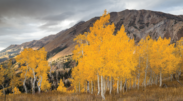
Enjoy nature’s paintbrush
along the Mount Nebo Loop
Jordan’s Mount Nebo is only 2,300 feet above sea level and is best described as a ridge. Utah’s Mount Nebo is 12,000 feet above sea level, and at that altitude, it might well have been the best place for Utah pioneers to view what they thought of as their own “promised land.”
Located between Payson and Nephi, Mount Nebo is actually a series of three peaks. It was long thought that the southern-most peak was the tallest, but during surveying in the 1970s, it emerged that the north peak, at 11,929 feet, was actually about 50 feet taller than the south, and about 100 feet higher than the middle peak. Once hikers reach any of those summits, there’s a ridge line that connects the three, but that hike is generally only recommended for well-equipped, experienced climbers.
One way to experience Mount Nebo and the many recreation opportunities around its base is to drive the Mount Nebo Scenic Byway (FS.USDA.gov), which runs between Payson and Nephi. The entire route is 38 miles long and can be driven straight through in about 90 minutes, but, given the many colorful stops along the way, it’s unlikely you’ll drive straight through.

At nearly 12,000 feet, Mount Nebo is the highest peak of Utah’s Wasatch Range
Coming from the north, take Interstate 15 through Utah County to Payson, exiting at 800 South and travel east to 600 East, then turn right to get on Nebo Loop Road, also known as Forest Road 015.
After a drive of about 15 miles, or 30 minutes, there’s a turnoff for Payson Lakes Campground (FS. USDA. Gov; to reserve, phone 1-877-444-6777 or visit Recreation.gov). With 98 single camp sites, 10 double sites and three sites that can host larger groups, it’s ideal for overnight camping.
Continuing along the loop, the turnoff for Nebo Bench Monument Trailhead is about 25 miles into the drive. This is a hard, strenuous hike that rewards hikers with stunning views. At the trailhead exit, turn right onto Mona Pole Road and continue about a quarter of a mile to the North Peak Trailhead. This is where hikers begin a 9-mile round-trip hike to the northernmost—and tallest—of the three peaks. The hike rises nearly 4,000 feet in altitude, but the first 3.5 miles up are fairly gradual. The difficult part comes during the final portion of the trek, when the trail rises 1,300 feet in less than a mile, and most of that is traveling over loose shale and black limestone. Plan on 6 to 8 hours.
There are also two other trails up to the Nebo peaks that approach from the south and west, but when considering difficulty and accessibility, the North Peak Trailhead is generally the most-used route, particularly for first-timers.

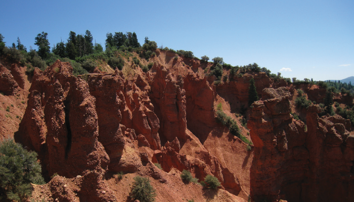
Devil’s Kitchen
is the “mini Bryce Canyon” of the Uinta National Forest
For those looking for great scenery but not a strenuous hike, continue south on Nebo Loop Road for another 5 miles to reach the Devil’s Kitchen. While that name might sound like it would be a daunting outdoor spot, its named for its scenic red-rock pillars and other formations. It features a paved trail, an observation deck and a picnic area. Use the trail to hike half a mile (round trip) to see red-rock hoodoos that have earned this spot the nickname of a mini Bryce Canyon.
After Devil’s Kitchen, Nebo Loop Road continues south for a few more miles before ending at State Route 132. Turning right there leads straight down to the town of Nephi, which is just 6 miles away.
Recreational opportunities abound in the Mount Nebo area, ranging from easier hikes such as the 2.7-mile Jones Ranch Trail to the more difficult 4.7-mile hike on the Bennie Creek Cutoff Trail. And if hikes, camping and views aren’t enough, the fall foliage will stop you in your tracks.
Whatever option you choose, after gazing out upon the vistas along the Mount Nebo Loop, you may agree with others that it is just the place to view the promised land.


