Grooving with the aspen groves of the Huntington-Eccles Canyons Scenic Byway
By Rebecca Chavez-Houck
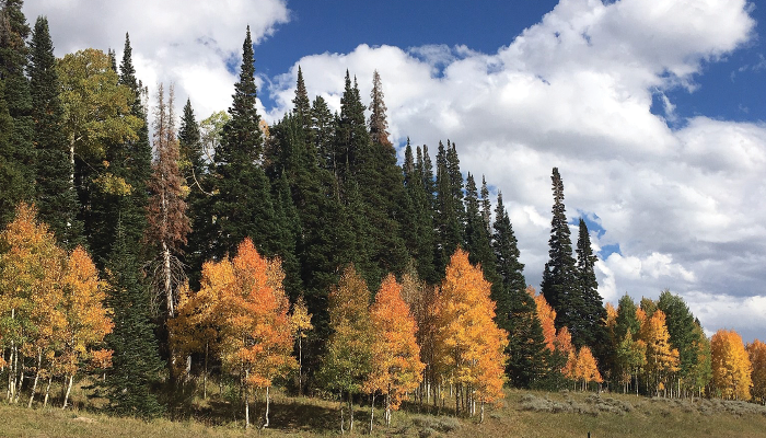
Just as we’re getting used to the rhythm of the summer camping season, a discernable chill settles in. Utah’s bright green deciduous forests ease into a brilliant canopy of gold, orange and red. Aspen groves, in particular, are best at putting on this color show. Not only do they wow us visually, they calm us when the wind wafts through their leaves while we sit around a campfire. I also listen for their tremblings as I fall asleep with our RV’s windows slightly ajar. Quaking aspen (Populus tremuloides) are truly “nature’s wind chimes.”
To catch their color show, many of us head up nearby canyons in the Wasatch mountains. However, I’ve often heard that the 86-mile Energy Loop, spanning from the town of Fairview to Huntington and Eccles canyons, is a “not to be missed” fall-foliage drive, so I took some time recently to explore the area. Here, you’ll find not only changing leaves, but historical sites, great hikes, good fishing and an array of campgrounds in the area, a few of which my husband, Martin, and I stayed at.
The Energy Loop—officially called the Huntington-Eccles Canyons Scenic Byway—is located within the Manti-La Sal National Forest of central Utah. We started our camping trip outside of Price at Scofield State Park (435-448-9449, StateParks.Utah.gov/parks/scofield), accessing it from State Route 96 off of U.S. 6. Due to heavy spring rains this year, the reservoir was were quite full. We stayed in the park’s Mountain View Campground, close to the reservoir marina, which features 34 total sites, one with electricity and water hookups, as well as nearby showers and flush toilets. Even though it was chilly, we saw a number of folks on kayaks and boats the day we were there.

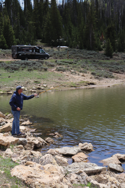
Martin Houck sinks a line at Boulger Reservoir with
the couple’s “View” RV
parked in the distance
This state park also offers updated campsites at Madsen Bay Campground that have both electricity and water hookups, but with less foliage between the sites than at Mountain View. After spending the night at Scofield, we continued south along UT 96, and then traveled west on UT 264. Along the way, there were 16 informative interpretive pullouts that share the history of the area.
Off of Utah 264 (also known as the Skyline Drive) is Lower Gooseberry Reservoir, where you’ll find two primitive campgrounds, Gooseberry Reservoir Campground and up on the hillside above the reservoir is the Gooseberry Campground (877-444-6777, FS.USDA.gov). Both have pit toilets and are “pack it in, pack it out” facilities. Gooseberry Campground, with its nine single sites and one group site for up to 40 people, is probably best for smaller rigs and tent camping. It’s nestled right in the middle of an aspen grove, so it’s probably pretty amazing to be there in the fall. Larger trailers and fifth-wheels will be more suited to the Gooseberry Reservoir Campground.
There’s evidence of the coal industry on this drive. Coal mining sustained many families in this region, notably the Skyline Mine. Below the mine is Electric Lake, which contains the submerged ghost town of Conellsville. There were a lot of anglers testing their luck at the lake, but Martin struck fishing gold when we stopped at nearby Boulger Reservoir (located on a dirt road off of Utah 31 just about a quarter mile west of Electric Lake).
We enjoyed a delicious meal of rainbow trout later that evening when we camped at Old Folks Flat Campground (21 miles north of Huntington on Utah 31, 877-444-6777, FS.USDA.gov). We had originally reserved Site 4 but found Site 2 more to our liking (there are only four single sites—three of which are reservable—and five group campsites, all of which are really nice). The campground has flush toilets but no hookups.
Our drive to Old Folks Flat Campground took in the prime area of Huntington Canyon. We also recommend checking out the site near the Huntington Reservoir dam where the Huntington mammoth was discovered on Aug. 8, 1988. You can learn more about it at the mammoth exhibit at the Utah State University Eastern Prehistoric Museum (155 E. Main, Price, 800-817-9949, USUEastern.edu/museum/exhibits/mammoth).

Fires help maintain the ecosystem of aspen groves, says Western Aspen Alliance director Paul Rogers
Aspen Groves Reborn Through Fire
Along the way, we noticed the scars from forest fires and pine beetle infestations that have taken their toll on the canyon’s trees. We asked Paul Rogers, the director of the Western Aspen Alliance (WAA), about the impact of forest fires on aspen groves, and he noted that fires help maintain the aspen groves’ ecosystem.
The WAA was first created by Utah State University and Forest Service scientists to disseminate research to managers and solicit feedback from the field. Its members now include researchers, managers, landowners and conservationists from the Western U.S. and Canada. The group focuses on the health of regional aspen groves, many of which are faced with drought and overconsumption of new tree shoots by herbivores (elk, deer, cattle and sheep).
Rogers says that a number of groves in the lower elevations on the Colorado Plateau are either dying or in bad health. Rogers encourages visitors to listen for bird calls and look for other animals that depend on the aspen.
“Healthy aspen are rich in biodiversity,” he says, “so if whole forests are dying or groves are unhealthy, you have an impact on the ecosystem of dependent plants and animals in the area.” The health of the aspen groves also affects water usage.
For more information, visit the WAA website, Western-Aspen-Alliance.org, which provides a wealth of information, including a field guide on its home page.
Less than a mile southeast of Old Folks Flat Campground (on Utah State Route 31), we stopped at the Stuart Guard Station—which is now a museum and visitor center—a must-see if you are traveling the area. However, it’s only open on summer weekends between Memorial Day and Labor Day. The guard station was constructed as part of a Civilian Conservation Corps project in 1933 and contains a variety of interpretive exhibits, photos and artifacts, as well as Forest Service memorabilia.
Additional primitive Forest Service campgrounds are located along the loop, including Flat Canyon Campground and Forks of the Huntington Campground (FS.USDA.gov).
We ended our byways weekend at Huntington State Park (2 miles northeast of Huntington on Utah State Route 10, 435-687-2491, StateParks.Utah.gov/parks/huntington). It’s a fully appointed campground with electric and water hookups as well as flush toilets and showers.
As we settled in for the night next to Huntington Lake, we watched the distant alpenglow alight the northern reaches of the San Rafael Swell. It’s something I hope you’ll be able to enjoy sometime this fall.
See you at the campground!


