A lonely highway reminds us what wild country looks like
By John Rasmuson
We find after years of struggle that we do not take a trip; a trip takes us.
—John Steinbeck
To take a trip on an airplane nowadays is to run a gauntlet, suffering for hours before emerging at the baggage claim carousel, battered and bedraggled. These trips take us between crowded, lookalike airports at disorienting speeds. Lay over in Kalamazoo? The airline decides, not us.
Steinbeck would have objected to the encapsulation of air travel. He wanted to see the sights along the blue highways, eat lunch in diners, and hobnob with the residents of rural towns across America. Accompanied by a poodle named Charley, he drove 10,000 miles on a road trip that generated a best-selling travelogue in 1962.
Travels with Charley in Search of America was on my mind as I planned a December trip to San Francisco. Without business to conduct and no particular timetable, I decided to forgo the airplane ordeal, eschew the tedium of I-80 through Reno, and drive across Nevada on “the loneliest road in America.”
I chose Highway 50 not because it was the antithesis of frenetic air travel, but because I have lately come to think of trips and destinations as being conjoined. In other words, the overriding concern was not so much where I was going as it was how I would get there. And at what pace. Another factor in the decision-making process was an upswell of nostalgia for the iconic American road trip of the mid-20th century (as experienced in the back seat of my father’s lumbering, green Buick.)
For the jaded frequent flier, the stretch of Highway 50 from Delta, Utah, to Carson City, Nevada, is an ideal, introductory road trip. It is short. 500 miles. It offers travelers a history lesson, desert scenery and solitude. It is called the loneliest road because not many choose to drive it—especially in winter—and not many still live in its isolated, 19th century mining towns. Any of them linked by Highway 50 could serve as the setting of an end-of-an-era movie like The Last Picture Show.
In the salad days of 1919, the same towns celebrated the arrival of an 80-vehicle, Army convoy dispatched from Washington, D.C., and bound for San Francisco on the 6-year-old Lincoln Highway.
That first transcontinental highway, which was built with private funds, was almost impassable west of Nebraska. Utah’s desert was especially difficult. “From Orr’s Ranch (west of Tooele), Utah, to Carson City, the road is one succession of dust, ruts, pits and holes” wrote Lt. Col. Dwight Eisenhower, one of the convoy’s 24 officers: The coast-to-coast trip took two months.
It made a lasting impression on Eisenhower as did the autobahns he saw in occupied Germany after World War II. “The old convoy had started me thinking about good, two-lane highways, but Germany had made me see the wisdom of broader ribbons across the land,” he wrote. As president, his views shaped the interstate highway network funded by the federal government in 1956.
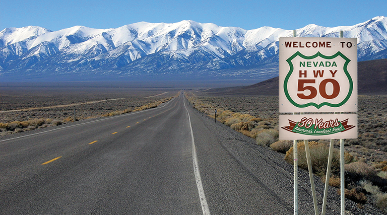
Eisenhower’s road-as-ribbon analogy is apt. (It evokes the 119-foot paper scroll on which Jack Kerouac typed On the Road.) For hundreds of miles, the two-lane highway unspools across the desert to a vanishing point in mountains that look like dark thunderheads on the horizon.

“Apart from the feathery con trails overhead and a spindly fence that follows the roadway, the boot print of modernity is absent.”
The land, empty under a vault of blue sky, is as quiet as a high school in July. It is haunted by Fremont Indians, Pony Express riders, silver miners, stockmen and Latter-day Saints pioneers. Their encounters with this wild place, Wallace Stegner—American novelist, historian and environmentalist—believed, forged character.
None of those pre-modern visitors has left a visible trace, not even a Lombardy Poplar, a pioneer favorite for windbreaks. Apart from the feathery con trails overhead and a spindly fence that follows the roadway, the boot print of modernity is absent: No train tracks, truck stops, cellphone towers or telephone poles. No scraps of retread rubber on the highway; no plastic water bottles littering the shoulder. The landscape is a nubbly carpet unfolding in shades of brown, green and gray. Yellowing bunch grass adds a fringe here and there, but it’s chiefly sagebrush as far as you can see.
And so it will be for a few more centuries. The sunbaked land won’t be bulldozed for a desert spa, survival camp, golf resort, Mars simulator or alfalfa field.
Why not? Lack of water is one reason. There is also an unmistakable sense that the wilderness has already achieved its highest and best use. “We simply need that wild country available to us even if we just drive up to the edge and look in,” wrote Stegner. Driving the loneliest road on a winter day is conducive to such meditations.
The first stop on my road trip was Great Basin National Park, a four-hour drive from Salt Lake City, just 60 miles shy of Ely, Nevada. The remote park is known for the Lehman Caves, ancient Bristlecone Pine trees, and stargazing par excellence. Park rangers conduct astronomy programs three nights a week during the summer season. This year’s three-day Astronomy Festival begins Sept. 17.
I topped off the gas tank in Ely and set out for Carson City, 400 miles and two gas stations away. I knew immediately I had made the right decision: more legroom than a first-class airplane seat; freedom to stop for a petroglyph or historical marker; uninterrupted scenic vistas; and an enveloping stillness. After Carson City, Highway 50 swung around Lake Tahoe, crossed the Sierra Nevada mountains, skirted Sacramento, thence to the coast where I was sorry to have my road trip end.
To steer clear of airports proved to be a satisfying decision even if it did add a few hours to the itinerary. I am late to the band wagon, however. According to MMGT Global, a travel consulting company, 22 percent of American vacationers chose road trips in 2015. The percentage rose to 39 a year later as increasing numbers sought to make the journey a destination.


