Santa Clara River Reserve hiking trails reveal lost traces of a vanished people.
It is hard to imagine—as you scream south on Interstate 15 toward St. George past the strip malls, golf courses and cookie-cutter subdivisions—that the red-hued sandstone cliffs and buttes here harbor secrets of long-since-disappeared villages and hamlets, some two millennia old.
For many, the crush of modern humans descending upon Utah’s beautiful landscape is incongruous with the desert landscape—it is seems somehow unnatural. But the reality is this land has beckoned humans for thousands of years.
There was a time, roughly a thousand years ago, when the St. George Basin had one of the largest populations anywhere in the state—thousands upon thousands of maize-growing families made their homes along the Virgin and Santa Clara rivers.
Locals refer to these ancients as the Virgin Anasazi, although archaeologists prefer the more politically correct term Ancestral Puebloans of the Virgin River country. They were most certainly cousins to the prehistoric residents of southeastern Utah now famous because of the Bears Ears National Monument designation.
The first farmers probably arrived in the St. George area around A.D. 1, give or take a couple hundred years. They might have arrived by way of an ancient travel corridor—the I-15 of its day—that extended from northern Arizona along the base of the Vermilion Cliffs, where they left distinctive images pecked into the cliffs that harkened to their homelands.
Over the decades and centuries that followed, they developed a complex social structure and intricate trade networks that connected them to distant lands and peoples. Scores of communities were packed along river bottoms and perched high on mesa tops with cliffs to protect them. Their society was every bit as complex and awe-inspiring as those to the east.
And there were lots of them—so many so that when punishing droughts descended on the region about A.D. 1250, there were simply too many people to feed and not enough water to grow crops. They had no choice but to leave, walking away from their ancestral homes.
“What?” you might ask. “So where is the evidence of this great society?”

The short answer is that the remnants of that ancient culture are mostly buried below or were ripped out during the course of building modern roads, homes and shopping centers. What makes a good house site today was also a good house site a thousand years ago. Consequently, there is not a whole lot left to remind us of how the ancients thrived in this desert landscape.
A few of the sites were investigated by archaeologists before they were lost. But the biggest treasure resulted from forward-thinking leaders in Santa Clara, Ivins and the St. George field offices of the Bureau of Land Management—all of them concerned about urban sprawl and the critical need for open space and recreation. In 1997, they set aside the 6,500-acre Santa Clara River Reserve, mostly for hiking and biking trails.
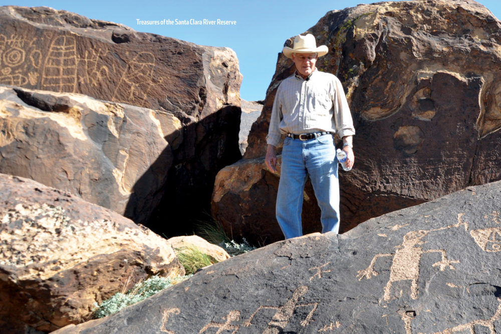
Whether they intended to or not, they preserved important remnants of Ancestral Puebloan hamlets perched on a mesa top overlooking the Santa Clara River. In addition, they protected hundreds of the finest prehistoric rock art images to be found anywhere in southwestern Utah—all with a drop-dead gorgeous scenic backdrop that must have inspired the ancients as it does us today.
In reality, the reserve now has 16 hiking and biking trails of varying skill levels, and archaeological sites can be found along most of them if you know what to look for. But one trail in particular—the 3.6-mile Tempi’po’op Trail—offers a glimpse into a prehistoric wonderland.
The trail wends its way past ancient houses—only the stone foundations remain after a millennium of decay, so use your imagination—and toward the edge of the cliff. You will notice a few petroglyphs on the flat volcanic surfaces next to the edge (please do not step on them).
But to enjoy the good art work, work your way off of the edge to the base of the highest cliff band—about 20 to 40 feet down in most places—where you will find a primitive trail that twists its way through lava boulders, each covered in scores of bizarre images harkening to a lost people in a forgotten time.
The rock-art images are scattered along a quarter mile or so of this cliff level, and the more you look, the more you will find. On every visit, I discover something new I haven’t seen before.

Plan on at least three hours to explore the rock art along this trail, more if you like to explore. There usually is plenty of parking at the Anasazi Valley Trailhead, where restrooms are an added convenience for families with children. And it can get hot even in the winter, so take plenty of water.
To get there, make your way west from St. George to Santa Clara and look for the Jacob Hamblin historic home in the downtown district. From that point, there are several routes into the reserve. But to get to the petroglyphs, continue on the main drag another 3.2 miles to the west (it turns into U.S. 91) and watch for the turnoff to the Anasazi Valley Trailhead.
The improved trail to the mesa top is easy for all ages (it is a little steep at the beginning, but levels out). The boulder scrambling, on the other hand, is more difficult.
For more information on hiking and biking in the reserve, contact the BLM St. George Field Office at 435-688-3200, or visit SantaClaraTrails.com.
Jerry D. Spangler is an archaeologist and executive director of the Colorado Plateau Archaeological Alliance, a nonprofit dedicated to preserving archaeological and historic sites on public lands.


